← Home · Geophysics

MASW / VS30 Shear Wave Velocity Testing in Canberra

Together, we solve the challenges of tomorrow.

EXPLORE →

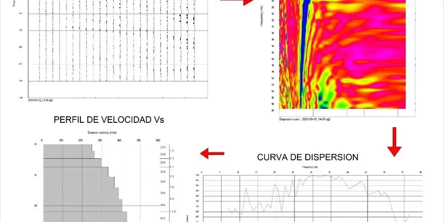
Canberra's subsurface isn't uniform. Deep Ordovician sediments butt against Silurian volcanics across short distances. A site in Belconnen can behave nothing like one in Tuggeranong. That contrast makes generic site classification dangerous. The seismic refraction method helps map bedrock depth, but for shear wave velocity profiling we deploy MASW. It captures Vs profiles down to 30 metres without boreholes. The data feeds directly into AS 1170.4 site class determination. For sites with highly variable fill over weathered rock, integrating MASW with CPT testing yields a continuous stiffness profile that neither method achieves alone.

VS30 alone is not enough. The velocity gradient in the top 10 metres often controls Canberra's site amplification more than the 30-metre average.

Method and coverage

A common mistake on Canberra projects is ordering a single downhole seismic test and assuming the Vs profile applies site-wide. That assumption fails on sloping blocks in suburbs like O'Malley or Red Hill. We see velocity inversions where stiff residual soils overlie deeply weathered, low-Vs material. MASW maps lateral variability efficiently. A linear array captures a 2D cross-section in one deployment. The Rayleigh wave dispersion curve is inverted to a 1D Vs profile at each midpoint. We process data using the multichannel approach specified by the Kansas Geological Survey framework. The entire workflow complies with NATA's ISO 17025 requirements. For sites where fill thickness exceeds 4 metres, we often pair the survey with test pits to ground-truth the top layer before finalising the inversion model.
MASW / VS30 Shear Wave Velocity Testing in Canberra
Technical reference image — Canberra

Regional considerations

The sedimentary basins beneath Canberra's northern suburbs behave differently from the weathered ignimbrite ridges south of Lake Burley Griffin. Belconnen sites over deep Quaternary alluvium can produce NEHRP class D or even E profiles. Civic and Barton, sitting on the Canberra Formation, typically yield class C results. The risk lies in assuming a class C designation for a pocket of softer material. An overestimated site class leads to underestimated seismic design actions. That error propagates through the structural design. The NCC references AS 1170.4, which in turn ties spectral shape factors directly to VS30. Getting that number wrong by 50 m/s changes the base shear. A surface-based liquefaction screening assessment also relies on the same Vs profile, making MASW a dual-purpose investment on sandy sites near the Molonglo River.

Need a geotechnical assessment?

Reply within 24h.

Email: contact@geotechnicalengineering1.co

Process video

Technical parameters

ParameterTypical value
Investigation depth (standard)30 m below surface
Source typeSledgehammer / weight drop, 8–10 kg
Array length23–69 m (24–48 geophones)
Geophone frequency4.5 Hz vertical component
Sampling interval0.5–1.0 ms typical
Record length2 seconds per shot
Dispersion analysisPhase velocity–frequency domain
Site class outputAS 1170.4 classes A–E

Complementary services

01

VS30 Site Classification for Structural Design

Complete MASW survey with dispersion processing, inversion, and a formal site class determination per AS 1170.4. Deliverables include 2D Vs cross-sections, average velocity profiles, and a signed engineering report suitable for building consent submission.

02

Seismic Microzonation and Site Response

Grid-based MASW campaigns covering multiple hectares. Used for subdivision planning, campus-scale developments, or infrastructure corridors. Outputs integrate with GIS layers and feed into 1D site response analyses for ground motion prediction.

Standards that apply

AS 1726:2017 – Geotechnical site investigations, AS 1170.4:2007 (R2018) – Earthquake actions in Australia, NEHRP (BSSC, 2020) – Site classification based on VS30, ASTM D7400-19 – Standard test methods for downhole seismic testing (reference for Vs interpretation)

Q&A

How does MASW compare to a downhole seismic test for Canberra's rock conditions?

MASW measures average Vs over a receiver spread and works well even where drilling is difficult, such as in the fractured Canberra Formation. Downhole testing gives a point measurement at the borehole location and requires a cased hole. MASW provides lateral coverage that a single downhole test cannot. On sites with shallow, steeply dipping rock, combining both methods is advisable: MASW for spatial coverage and downhole for depth-specific verification.

What does a typical MASW survey cost in Canberra?

For a standard single-array MASW survey producing one VS30 profile, the fee ranges from AU$2,930 to AU$4,940 depending on array length, site access conditions, and whether a traffic control plan is required. Multi-line or grid surveys for microzonation are priced per linear metre after the first line.

How long does it take to get results from a MASW survey?

Fieldwork for a single array typically completes in half a day. Processing the dispersion curves, running the inversion, and interpreting the Vs profile takes an additional three to five working days. The final report with AS 1170.4 site classification is delivered within one week of field acquisition, provided weather conditions during the survey were acceptable.

Location and service area

We serve projects across Canberra and its metropolitan area.

View larger map