A civil contractor recently broke ground on a multi-level development near Lake Burley Griffin and encountered suspect subsurface conditions within the first few metres—variable fill over deeply weathered Silurian volcanics. Instead of relying on a sparse grid of boreholes alone, the project team commissioned a seismic refraction survey to map the bedrock profile continuously across the entire footprint. Seismic tomography in Canberra fills the gap between point-source investigations and the lateral heterogeneity that defines much of the region’s geology. The technique measures compressional and shear wave velocities along densely sampled geophone lines, then inverts the travel-time data to produce two- or three-dimensional velocity models. These models reveal rippability limits, fracture zones, and stiffness contrasts that directly inform excavation planning and foundation depth decisions. For sites where reflection methods are required to image deeper stratigraphy—such as proposed tunnel alignments or deep basement excavations—the combination of refraction and reflection tomography delivers a continuous subsurface image from the near-surface to depths exceeding 80 metres, all without a single drill hole being placed in the wrong location.
Seismic tomography delivers continuous velocity models across a site, reducing the blind spots that borehole-only investigations leave in Canberra’s highly variable weathered rock profiles.
Regional considerations
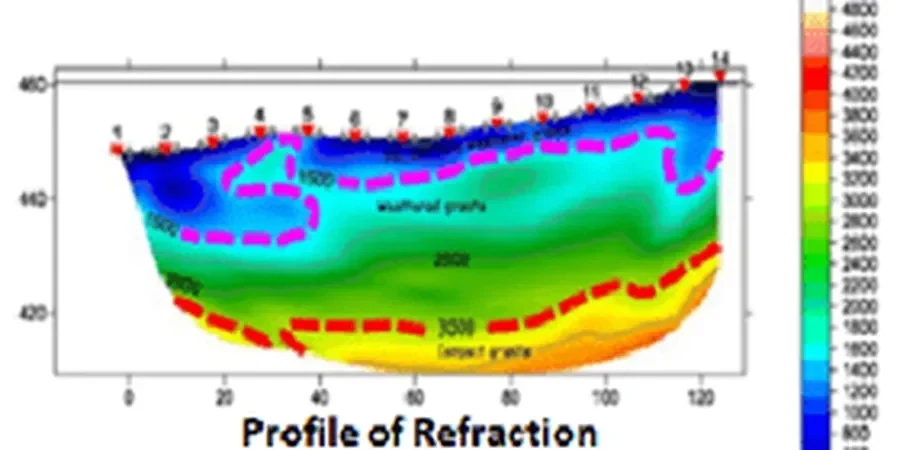
Two sites in Canberra separated by less than a kilometre can present entirely different seismic velocity structures. A greenfield parcel in Gungahlin underlain by the Canberra Formation might show competent metasediment within 2 metres of the surface, while a redevelopment site in Kingston on paleochannel deposits of the Jerrabomberra Wetlands could hide 15 metres of soft alluvium that generates a velocity inversion invisible to standard refraction interpretation. Missing that velocity inversion leads to underestimated settlement, mischaracterised Site Class, and foundation designs that carry latent risk. Seismic tomography addresses this by combining refraction first-break analysis with reflection processing to image both the high-velocity bedrock surface and any low-velocity layers beneath it. The resulting velocity model assigns a stiffness to every cell in the subsurface grid, letting the geotechnical engineer identify zones where bearing capacity degrades, where excavation conditions change, or where seismic amplification may concentrate. On hillside sites in suburbs like O’Malley or Red Hill, the same dataset supports slope stability analysis by mapping the thickness of colluvium over dipping bedrock—a geometry that has contributed to historical instability along several Canberra nature park boundaries.
Q&A
How does seismic tomography reduce the number of boreholes needed on a Canberra site?
Seismic tomography provides continuous subsurface velocity information between boreholes, so the investigation shifts from a drilling-heavy approach to a targeted strategy where boreholes are positioned to calibrate the geophysical model at key locations. On a typical commercial site in Canberra, this often reduces the borehole count by 30 to 40 percent while improving the lateral coverage of the ground model, because the tomographic profile captures variations that would be missed by a grid of discrete drill points alone.
Can seismic refraction and reflection surveys be conducted in built-up areas of Canberra?
Yes, seismic tomography adapts well to urban environments. Refraction surveys use a sledgehammer or weight-drop source that generates minimal vibration beyond the survey line, and no drilling or heavy machinery is required for the geophone array. Reflection surveys employ slightly larger sources but still operate within council noise and vibration guidelines. The equipment fits within a standard road reserve or construction site, and the crew manages traffic and pedestrian access during acquisition.
What depth of investigation can seismic tomography reach in Canberra’s geology?
Refraction tomography typically images 15 to 45 metres depth depending on the geophone spread length and the velocity structure of the site—sufficient to map the weathered rock to fresh bedrock transition across most of the ACT. Reflection seismic, when applied with a longer array and higher-energy source, can resolve stratigraphy at 80 to 150 metres depth, making it suitable for deep infrastructure projects such as proposed light rail tunnels or major stormwater diversion structures.
What does seismic tomography cost for a typical site investigation in Canberra?
Seismic tomography surveys in Canberra generally range from AU$4,040 to AU$8,550 depending on the survey length, whether only refraction or both refraction and reflection are required, and the complexity of the processing. A basic refraction profile for a single-building site falls toward the lower end, while a combined refraction-reflection survey with shear-wave acquisition and detailed tomographic inversion sits at the upper end of the range.